Date/Time
Date(s) - 23/09/2019 - 28/09/2019
9:00 am - 5:00 pm
Location
Civil Department Seminar Hall
Categories
INDUSTRIAL TRAININGON “REMOTE SENSING AND GIS” FROM 23.9.19 TO 28.9.19
Industrial training on “Remote sensing and GIS” was arranged for third year Civil students from 23.9.19 to 28.9.19. Kcube Coimbatore conducted the training for the students from 9.00A.M to 5.00 P.M on the scheduled dates.
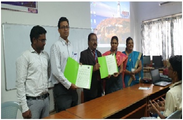
The resource person for the guest lecture was Mr.Sitanshu, CEO and director of Kcube Consultancy private Limited. As the sign for industrial tie-up MoU is signed between Sona College of Technology Kcube Consultancy private Limited in the presence of Principal. Mr.Sitanshu explained about the significance of training and the benefits that could be derived through MoU by students Community. In total 31 students were get benefited from the training and participated with great enthusiasm and interest. To start with the training, installation procedure was taught to the students. Since the software QGIS was the open source software students were asked to install the software individually. Basic operations like creation of vector and raster layer and merging layers were taught during the afternoon session of the first day. Order and procedure of arranging lines, points and polygons were taught with the illustration. On Day 2 different tasks like creating spatial bookmarks, learning about vector properties, and identification of different features were practiced with the different maps. Tamil Nadu map was taken case study and different bookmarks like population, area were calculated using the different options taught in QGIS.Projection, symbology, labelling and georeferencing were taught during Day 3 and usage of symbols and labels like districts, rivers, vegetation were marked on TamilNadu district map. On Day 4 querying database, vector bender and installation of plug-ins were taught with exercise problems. Map of Sona campus was taken from Google pro earth and the options were applied to the campus map. On day 5, analysis, research, geometry, data management, geoprocessing tools were learnt with exercise problems. TN map was taken to work out the options. On Day 6, importing and exporting data in QGIS was taught with GRASS tool option. Each block of Sona Campus was marked in QGIS and students were presented their maps as teams. Each day, the training is ended up with the quiz session and the answers were discussed during the next day of the session. At the end of the day, students were given the presentation about the learning outcomes of the training. Final day ended up with the vote of thanks by students and good feedback was received from trainer and students.
A student report on the talk stated that “Remote sensing is the emerging area of Civil Engineering in terms of more opportunities and the training gave an insight about practical applications of such tool using QGIS. It also shed light on different project areas and internships that can be taken by students as part of their academic performance”.